You could be forgiven for thinking the Atlantic had tired of sweeping the shores and decided to reclaim the land by air-drop. It's been pretty soggy here for the past month or so. Not, I'll grant you, as bad as Somerset, Dorset or further east still, but still relentlessly soggy. The skies have been grey and weepy, the ground growing increasingly squelchy, and the river Bovey has been up and down like a back-bencher in a lively parliamentary debate. We're fortunate to live a couple of house-heights above the river, so flooding is the least of our worries, but there are a few buildings in town which tread a delicate line along the river's edge and are a salutary lesson not to buy property in a flood-plain (as if the lesson were needed)!
We're quite high up the catchment and the rivers here are short and inclined to spate conditions, so flooding never lasts that long on any one occasion, but it can repeat over and over again if the weather gets it just so. Just before Christmas (doesn't that seem a long time ago?!) I had an hour of free time just before it got dark, and the Bovey was overtopping the banks - so I managed to shoot out and take some pictures. The river is bottle-necked where the west-bound road crosses just below the town centre. Once there was a ford there beside the old mill, now there's a neat little hump-backed bridge, and a flood-bank to protect the houses on the west side of the river. As it's quite an old bridge, there's a two-arch span, and this constrains the water perfectly, so it ponds back and spills over the adjacent playing field. By the time I got there the water was about welly-top depth across the end of the park - the brand new, newly-gravelled cyclepath only indicated by a forlorn sign asking cyclists to respect the pedestrians on the track. The gravel had been neatly swept off the path and deposited in a sweeping system of deposit bars to gladden the heart of a fluvial morphologist. To cap it all, there was a Cormorant fishing on the field.
 |
| Living here would make me nervous. But I wouldn't live here anyway! |
 |
| The old mill - now home to the Devon Guild of Craftsmen - lives on the edge. You wonder how often it flooded in times past... |
 |
| The road-bridge through town |
 |
| No conflicts today... |
 |
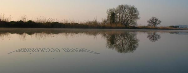
| Looking across the cycle path |
 |
| Looking south, towards the bridge |
Further upstream the field rises slightly, and then there is another narrow point where the A382 crosses the river - this time in a single-span bridge, but with a carefully-constructed underpass for cyclists and walkers to avoid the road-crossing. Not today, though.
 |
| Low and narrow, yes. I think I'd prefer to take my chances crossing the road. |
By the time I reached my intended goal, the light was appalling, so most of the photos were on delayed timer and at half a second or more exposure time. The weir was a spectacular sight: the difference in water height between top and bottom of weir is usually a good 1.5m; today, more like half a metre. The water surged over the top of the path, submerging the entire woodland floor across the bend where the weir sits - normally a well-trodden sandy patch where dogs frolic and children play chase. In the gathering gloom it was a distinctly suspect proposition to venture in and take photographs, so I contented myself with some atmospheric pictures of 'the end of the path as we know it'. Given the exposure times, the tripod would no doubt have been so shaken around by the water that the photos would be even worse in any case!
 |
| The weir: normally a well-trodden relaxing spot |
 |
| The weir itself is hiding under that bank of water just above and right of centre |
 |
| The end of the line... |